Indoor Google Maps at Toronto Pearson is now available to enhance the passenger experience at the Canadian airport.
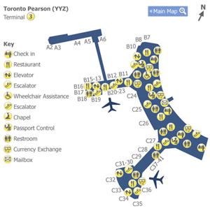 Toronto Pearson is one of the first Canadian airports to offer indoor Google Maps.
Passengers can now use Google Maps and Google Maps for mobile, to discover key points of interest in the areas pre-security and post-security in both Terminals, before they board their flights.
Indoor Google Maps enables passengers to zoom in and see the floor plans of the airport to locate amenities, restaurants and retail locations.
The aim is to help facilitate passenger flow and ease navigation for passengers of any language, and provide a hassle-free passenger experience.
Scott Collier, V.P. of Customer and Terminal Services, Greater Toronto Airports Authority (GTAA) says “It’s important that we connect with passengers using the technology and platforms that meet their needs and exceed their expectations.”
Toronto airport
Toronto Pearson International Airport (YYZ) is located 22.5km northwest of Downtown Toronto and serves the province of Ontario that has 12 Million of inhabitants.
Toronto Pearson is the largest and busiest airport in Canada. In 2013, it handled 36,109,469 passengers and 435,592 aircraft movements.It is the world’s 35th-busiest airport by total passenger traffic, 23rd-busiest airport by international passenger traffic, and 18th-busiest airport by flights. Pearson is a major North American global gateway, handling more international passengers than any airport in North America other than John F. Kennedy International Airport.
[su_divider]